The Central Valley Landfill in Kettleman City, CA is surrounded in more controversy as it looks to expand further into surrounding farm communities. Senators Boxer and Feinstein are trying to postpone the expansion until research can be done into the possible linkages between the location of the state's largest landfill and birth defects and environmental pollution in the nearby towns. The use of spatial analysis in GIS can help determine the "suitability" of the land on which the landfill proposes to grow, both for the safety of the people and for the function of the facility to hold over "400,000 tons of waste" (data for 2009) including materials containing cancer causing PCBs.
Studies have been conducted in the towns adjacent to the landfill, and researchers from the Department of Public Health concluded that the frequency of birth defects has no direct tie to the proximity of the landfill. This claim that birth defects are "not higher than expected" rides on the back of several reports stating that the large landfill is improperly maintained. The water supply in those cities alone is known to contain elevated levels of arsenic, though its cause, whether from overuse of pesticides in farming or the landfill's toxic holdings, is unknown. Although it seems to be a near consensus by state agencies as to the lack of a correlation to health issues and the landfill, citizens of the towns and Senator Boxer aren't set on believing the results. Locals are already concerned with their exposure to pollutants from their agrarian environment, as well as their poor water supply, but with the constant influx of hazardous waste into the Central VAlley Landfill, the concern is exacerbated and needs to be fully and directly addressed.
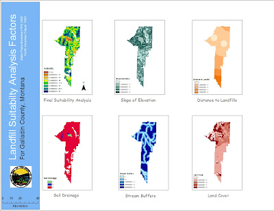
The people of Kettleman City need clearer and more succinct data. Its unlikely that a high number of birth defects or various other health issues is completely independent of the nearby landfill that has accrued numerous safety violations for improperly operated waste ponds and unusually high levels of radiation. With state agencies conducting studies without much of their knowledge and with vague results that eliminate them from blame, it's reasonable to see why there is so much mistrust and concern from local farmers. The data Feinstein and Boxer's teams need to gather needs to be of higher quality, and regarding the main factors of concern, like toxic leakage from the dump and where it's ending up in the surrounding land. With better information from focused research teams, GIS can be implemented to consolidate this data into easily understandable formats, like the six maps created in the tutorial.
These maps can pinpoint the drainage of the soil around the landfill and the externalities of that drainage of waste effluent on the land it seeps into, as well as the possible zones of contamination in regards to arsenic or PCB materials overlaid on maps of the city of county. These would allow a format to display the data publicly, thus allowing for critique and review of the research. And the conciseness of the data into a color coded map of a land parcel with which the people are familiar will provide all the people of Kettleman City with an understanding of the results.
Such spatial analysis lays evident the egregious faults of the landfill, but also the natural offenders aiding in the threat, like slope percent and land cover types. This information, gathered from GIS raster and spatial analysis, can help people make informed decisions about where to live, work, play. It'll also help Boxer and Feinstein make the decision about whether they will allow the landfill to expand its site and capacity further into the communities on which it borders. GIS is a valuable tool here, not solely for the administrators of this project, but for the people who voice real concerns and demand real answers to the alarming health problems in their communities. Here's to hoping the moratorium provides time to gather more conclusive results for the EPA and the people of Kettleman City to determine whether a 3.2 mile expansion could pose a severe health risk to the surrounding community. And when the numbers are all measured, GIS can be a more than capable tool in the calculation and presentation of correlations and relationships between variables and outcomes.
No comments:
Post a Comment